Eruption in Eyjafjallajokull 2010
Eyjafjallajokull glacier eruption
On March 20th 2010 (spring equinox), shortly before midnight, a half a kilometre long fissure opened up and an eruption started just to the west of the hiking trail in Eyjafjallajokull glacier. Earthquakes and tremours had been monitored since the summer of 2009, and the authorities were well prepared for the measures to be taken in case of an eruption. People were temporarily evacuated from the area and roads were closed. They were opened again in the afternoon. Scientists say, that this erution probably will count among the small ones. Lava started flowing across the hiking trail, down into the Hrunagil gorge on the 22nd, melting snow and causing temporary swelling of river Krossa. The trail is thus closed and it depends on the duration of the eruption, when it will be passable again.
Molten lava flow
On March 31st a 500 metres’ long eruptive fissure opened up a bit further northwest of the original fissure, which continued erupting. Molten lava flowed from the new fissure down into the Hvannargil gorge further north and added to the lava volume. The police and the rescue corps present decided to evacuate the nearest areas of the fissures. The whole mountain is unstable, and noone knows how it is going to develope. Those who visit the area have to realize the risk and be prepared for the worst.
April 13th – 14th 2010. No emission of lava from the fissure of March 31st. Eruption pause or end.
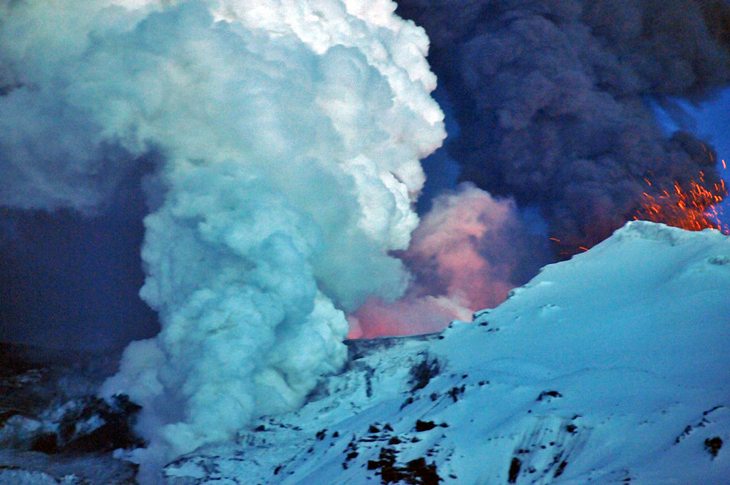
April 14th 2010. Shortly after midnight the mountain massif Eyjafjoll’s caldera started erupting. Flood waves rushed in two directions, mainly to the north into river Markarfljot’s wide valley, threatening farm communities and communications on rd #1, which was removed partly to save a relatively new bridge. Approximately 700 people were evacuated from their homes. The flood wave to the south threatens an inabited area around farm Thorvaldseyri, and will cause damage to rd #1, fields and meadows. The westerly winds carried ash and tephra eastwards, where large areas were covered. It is expected that the tephra distribution might disturb air communications to Northern Europe (Scandinavia).
May 3rd 2010. The last few days, one crater has been active in one of the ice cauldrons. Lava has been flowing to the north under the glacier tongue Gigjokull and increasing meltwater on the outwash plain. Today the temperature of the main glacial river, Markarfljot, was measured 11-17°C at the old bridge (1934).
Modi and Magni are two of the two youngest craters in Iceland, created in the Eyjafjallajokull volcanic eruption in 2010.
A German research plane flew to the southeast along the ash plume, which is carried at relarively low altitudes (>20 thousand feet), and reported hight density of the ash all the way down to the latitude 60°N, which might cause some disruptions of flights. Airports in Ireland and Scotland were closed as a result (May 4th and 5th).
According to scientists, the eruption is now more intense than in the beginning, but the ash (tephra) distribution is less likely to cause trouble because of coarser particles.
May 23rd 2010. The eruption has been dwindling during the week. A reporter flew over the crater in the afternoon and saw no sign of activity. The volcano has paused or the eruption is over.
Volcanic eruptions in Iceland
Eruption in Icelandic
